|
|
About SCEC | Research | Resources | Learn & Prepare | |||||||
|
A Comparison of the February 28, 2001, Nisqually, Washington, and January 17, 1994, Northridge, California Earthquakes
When large earthquakes happen in other areas of the world, SCEC is often asked questions such as, "What would the damage have been if it had happened in southern California?" or, "Why was there so much damage (in the other area) even though the magnitude of the earthquake was not that large?" After the recent earthquake in Washington state, SCEC was asked an unusual question: "Why was the damage in the Washington so much less than the damage caused by the 1994 Northridge earthquake, when their magnitudes were so similar-- 6.8 vs. 6.7?" This article presents a comparison of the geological aspects of the two earthquakes, which account for most of the differences in resulting damage.
The Puget Sound region of Washington state was jolted from its
morning routine at Soon after the shaking stopped, it became clear that the damage was less than might have been expected from an earthquake of this magnitude if it had occurred in a similarly populated region of southern California. This event, named the Nisqually earthquake for a river delta near its epicenter at the southern end of Puget Sound, was actually slightly larger than the Northridge earthquake. Yet Northridge, which had a magnitude 6.7, was the costliest disaster in U.S. history with an economic loss of $40 billion. Based on preliminary reports, it appears that the loss in the Nisqually earthquake will total only $2 billion. Likewise, only one death, a heart attack victim, was reported in the Seattle area, while 57 people lost their lives in the Northridge earthquake. Was this because the Seattle area was better prepared for earthquakes than the Los Angeles area? Or was it due to differences in the earthquakes themselves?
Much of the difference in the total damage
caused by the Nisqually and the Northridge earthquakes can be
attributed to the Nisqually earthquake's location -- not that
of its epicenter, but rather, the depth of its hypocenter.
The Northridge earthquake had a hypocentral depth of
The fact that western Washington state can experience such deep earthquakes, while southern California cannot, is the direct result of the tectonic environment found in each region. The sense of fault slip for the Nisqually earthquake was what geologists call "normal," meaning that the ground above the tilted fault plane moved downward relative to the material beneath the plane. This type of motion is typically found in extensional tectonic environments -- places where the crust is being stretched and pulled apart. That may seem out of place in the Pacific Northwest, where the oceanic Juan de Fuca plate subducts beneath the continental North American plate, but that collision of plates creates the bending stresses necessary to cause extension within the Juan de Fuca plate, where the Nisqually earthquake occurred.
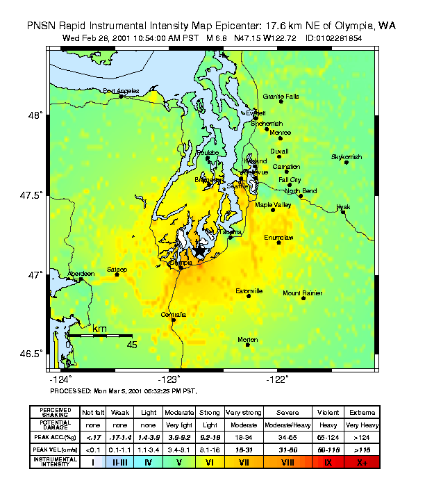
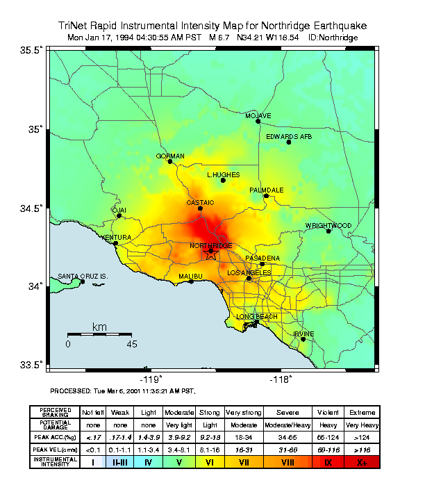
Ground-motion data from seismometers across Washington state were processed by the U.S. Geological Survey to create a shaking intensity map (ShakeMap). This map is compared in the figure on the right with a similar map from the Northridge earthquake. One can see that the total area of potentially damaging shaking (yellow and warmer colors) was fairly similar for the two events, but the area of high-intensity shaking for the Northridge earthquake, shown in red, was essentially absent for the Nisqually event. The difference in these maps is primarily the result of the difference in hypocentral depths of the two earthquakes. Given that the Nisqually earthquake occurred 52 kilometers beneath the suface, someone at its epicenter would be at the same distance from the event as someone 45 kilometers away from the Northridge epicenter. Both of these locations have a similar color (yellow-orange) on the shakemaps. This same pattern is reflected in the Community
Internet Intensity Maps (aka "Did You Feel It?")
for each earthquake. Reports from the Nisqually earthquake show a distribution
much like that seen in the intensity map -- a large expanse of
"very strong" shaking (Intensity VII), but no reports of severe
or violent shaking (Intensities VIII or IX), even in those places nearest the epicenter.
In the Northridge earthquake, residents in the
epicentral region (and some areas farther afield) reported severe,
even violent, shaking (Intensities VIII or IX), while communities farther away experienced
more moderate intensities. (A public
lecture on both ShakeMap
and the Community
Internet Intensity Maps will be given by David Wald on Thursday, March 15, at Caltech.)
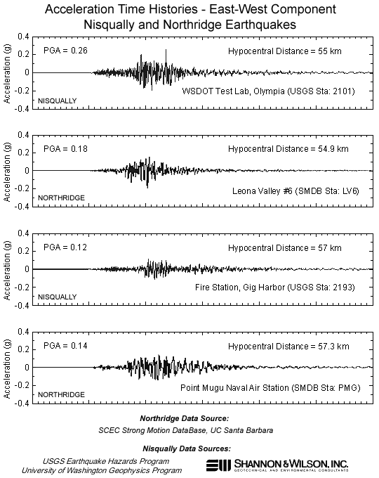
It is possible to take this a step further, and look at the ground accelerations recorded during each earthquake at locations with similar hypocentral distances. A plot of acceleration time histories can be seen at right. It shows the records of two strong-motion instruments from the Nisqually earthquake, each compared with a Northridge earthquake record made by a similar instrument from a similar hypocentral distance. Though it's impossible to draw sweeping conclusions from such a limited sample, you can at least that there are no radical differences in the accelerations experienced at similar hypocentral distances from these earthquakes.
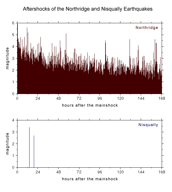
There was another striking difference between
these two earthquakes that became apparent soon after the Nisqually
earthquake struck. Whereas the Northridge earthquake was followed
by hundreds of smaller It turns out that the dearth of Nisqually aftershocks came as no real surprise to seismologists. Previous large earthquakes at this depth in the subducting Juan de Fuca slab, in 1949 and 1965, were followed by very limited aftershock activity, so the Nisqually aftershock sequence, or lack thereof, is really quite typical. Likewise, the Northridge aftershock sequence was in no way unusual compared to the average activity of southern California aftershock sequences. Thus, the obvious difference between the two aftershock sequences reflects the underlying difference in the source of each mainshock -- one in the subducting oceanic slab beneath western Washington, the other in the comparatively shallow, brittle crust of southern California.
|
|||||||||||

|
Created in the SCEC |
|
© 2025 Privacy Policy and Accessibility Policy |