SCEC logo SCEC INSTANeT News
Hokudan-Town Earthquake Memorial Park (Page 1)

In mid-May, 2000, SCEC Associate Director for Outreach Mark Benthien attended Hazards 2000, a workshop held in Tokushima, Japan, organized by the Natural Hazards Society. During his stay, Benthien was able to visit the Hokudan-Town Earthquake Memorial Park, on the west coast of Awaji Island just south of Kobe. This museum and park is a memorial to the people who died during the January 17, 1995 Magnitude 6.9 Hyogoken Nambu earthquake (also known as the "Great Hanshin-Awaji Earthquake Disaster", or simply the "Kobe earthquake").  Several faults were involved in this earthquake, including the Nojima fault which passes through Hokudan.  In this small town alone 39 people died. As a reminder of those who lost their lives and of the destruction earthquakes cause, the fault scarp exposed in Hokudan has been enclosed inside a long greenhouse-type building for present and future generations to view. A house which was damaged by this fault is also part of the memorial park.

Pictures of the museum and park are shown on this and three additional pages. In addition, video tours of the memorial and a video presentation shown at the museum are included. Real Player 8 is needed to view these clips.

Page 1: Photos from outside the memorial and of the fault just after the earthquake and as it is preserved now. Also a 2 1/2 minute video tour of the fault building.

Page 2: Additional photos from inside the fault museum, showing offset gullies, footpaths, and tree lines.

Page 3: Photos of the trench that has been excavated at the south end of the building, allowing visitors to see a profile of the fault. Also shown are pictures or two of the many displays located throughout the building.

Page 4: Photos of the damaged house located at the southern end of the fault building, now a part of the memorial. Also a 1 minute video tour of the property and a new house being built near the fault.

Video documentary (in Japanese, 10 minutes) showing scenes of the damage caused by the earthquake and the construction of the Earthquake Memorial Park. The images are vivid enough to understand without translation.

For more information about the Hyogoken Nambu earthquake, visit these sites:

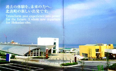
Main plaza of the memorial park. The fault scarp preservation building is on the left. The yellow building on the right is a gift shop and restaurant.

RealVideo Tour #1

To view a 2 1/2 minute video taken while at the museum, click here.


You will need Real Player 8 to view this video.


Scenes from the video:


1) Main plaza

2) Large relief map showing Awaji Island and surrounding areas.

3) Display showing buckled road just after the earthquake, and then footage of the fault now enclosed by the museum.

4) Gully offset by the fault.

5) Moving model of the fault motion during the earthquake.

6) View of the southern half of the building.

7) Close up of a wall map showing faults in the Awaji area

8) Horizontal displacement of a footpath

9) View from the south end of the building

10) Excavated section of the fault where the fault can be seen in profile.

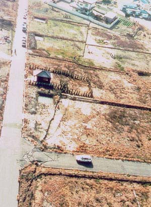
Aerial photo shortly after the earthquake. Notice the buckled road, offset tree lines, and house at the top of the picture.

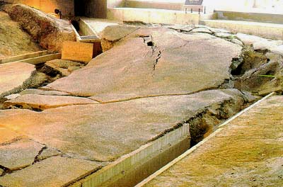
This photo is part of a display at the north end of the fault enclosure. Compare this photo with the current photo (next). The following text was also on the display:

"The Nojima earthquake fault, trending from Nashimoto Town, crosses under a road paved with asphalt. Motion along the fault caused about 50 cm of vertical displacement and up to 1.3 m of lateral displacement to the right in the road. Gutters on both sides of the road clearly reveal lateral dispacement. Along the earthquake fault, the road was pushed and pulled by earthquake motion as bulges appeared in the Inland side and the shore side sank to form a large hollow. The fractured road creates a strong impression of the power of fault behavior during the 1995 Hyogoken Nambu earthquake."

 
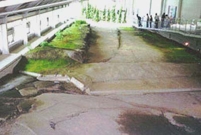
Compare this photo taken on 5/23/00 with the image above taken in January, 1995.
 
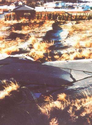
Close-up of the buckled road.


[Next set of pictures]


Phone 213/740-5843
Fax 213/740-0011
e-mail: SCECinfo@usc.edu